28146 Parallax Inc, 28146 Datasheet - Page 6
28146
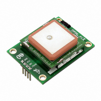
Manufacturer Part Number
28146
Description
MODULE RECEIVER PARALLAX GPS
Manufacturer
Parallax Inc
Datasheet
1.28146.pdf
(11 pages)
Specifications of 28146
Frequency
1.575GHz
Sensitivity
-139dBm
Modulation Or Protocol
GPS
Applications
GPS
Current - Receiving
115mA
Data Interface
PCB, Through Hole
Antenna Connector
On-Board, Chip
Voltage - Supply
4.5 V ~ 5.5 V
Operating Temperature
-40°C ~ 85°C
Package / Case
Module
Product
Microcontroller Accessories
Lead Free Status / RoHS Status
Lead free / RoHS Compliant
Features
-
Memory Size
-
Data Rate - Maximum
-
Lead Free Status / Rohs Status
Lead free / RoHS Compliant


Parallax GPS Receiver Module * Revision 1.1
altitude using GPS may introduce an accuracy error of 1.5 times the receiver’s position accuracy (in
the case of our GPS Receiver Module, this corresponds to about +/-20 meters in the vertical direction).
GPS signals work in the microwave radio band. They can pass through glass, but are absorbed by
water molecules (wood, heavy foliage) and reflect off concrete, steel, and rock. This means that GPS
units have trouble operating in rain forests, urban jungles, deep canyons, inside automobiles and
boats, and in heavy snowfall - among other things. These environmental obstacles degrade positional
accuracy or make it impossible to get a fix on your location.
Most GPS receivers output a stream of data so that it can be used and interpreted by other devices.
The most common format (and used by our GPS Receiver Module in “Raw Mode”) is NMEA0183
(National Marine Electronics Association, http://www.nmea.org/), developed for data communications
between marine instruments. Some receivers also have proprietary data formats which are used (in
the case of navigation receivers) to transfer waypoint lists, track logs, and other data between the GPS
and a computer. Such proprietary formats are not covered by the NMEA standard.
The NMEA0183 is provided as a series of comma-delimited ASCII strings, each preceded with an
identifying header. The data is transmitted as a 4800bps string of 8-bit ASCII characters. Thus, any
microcontroller with a serial port can extract data from a GPS module. But, modules do not produce
"plain text" location information. Instead, they create standardized "sentences," such as:
$GPGGA,170834,4124.8963,N,08151.6838,W,1,05,1.5,280.2,M,-34.0,M,,,*75
$GPGSA,A,3,19,28,14,18,27,22,31,39,,,,,1.7,1.0,1.3*34
$GPGSV,3,2,11,14,25,170,00,16,57,208,39,18,67,296,40,19,40,246,00*74
$GPRMC,220516,A,5133.82,N,00042.24,W,173.8,231.8,130694,004.2,W*70
Programmers can parse these strings to obtain their desired information, including time, date, latitude,
longitude, speed, and altitude. For more information on NMEA0183 sentence information, visit
http://home.mira.net/~gnb/gps/nmea.html.
The "Smart Mode” of the Parallax GPS Receiver Module will receive commands from the user and
automatically parse the necessary NMEA0183 strings to calculate the desired information for the user.
Using the example code provided at the end of this document will output parsed data in the following
format (this screenshot was taken while driving through Lone Pine, California):
Parallax GPS Receiver Module Test Application
---------------------------------------------
Acquired Satellites: 8
Direction of Travel: 338.1°
Hardware Version: 1.0
Firmware Version: 1.0
Signal Valid: Yes
Local Time: 23:28:45
Local Date: 09 MAR 2006
Longitude: 118° 03' 35.6" W (-118.0599 )
Latitude: 036° 35' 55.3" N ( 36.5986 )
Altitude: 1143.2 meters
Speed: 33.8 Knots
( 38.8 MPH )
( 3750.6 feet )
Page 6/11
Related parts for 28146
Image
Part Number
Description
Manufacturer
Datasheet
Request
R


Part Number:
Description:
Microcontroller Modules & Accessories DISCONTINUED BY PARALLAX
Manufacturer:
Parallax Inc

Part Number:
Description:
BOOK UNDERSTANDING SIGNALS
Manufacturer:
Parallax Inc
Datasheet:


Part Number:
Description:
COMPETITION RING FOR SUMOBOT
Manufacturer:
Parallax Inc
Datasheet:


Part Number:
Description:
TEXT INFRARED REMOTE FOR BOE-BOT
Manufacturer:
Parallax Inc
Datasheet:
Part Number:
Description:
BOARD EXPERIMENT+LCD NX-1000
Manufacturer:
Parallax Inc
Datasheet:

Part Number:
Description:
CONTROLLER 16SERVO MOTOR CONTROL
Manufacturer:
Parallax Inc
Datasheet:

Part Number:
Description:
BASIC STAMP LOGIC ANALYZER
Manufacturer:
Parallax Inc
Datasheet:

Part Number:
Description:
IC MCU 2K FLASH 50MHZ SO-18
Manufacturer:
Parallax Inc
Datasheet: